
Seafloor Structures and Static Stress Changes Associated With Two Recent Earthquakes in Offshore Southern Batangas, Philippines
Summary
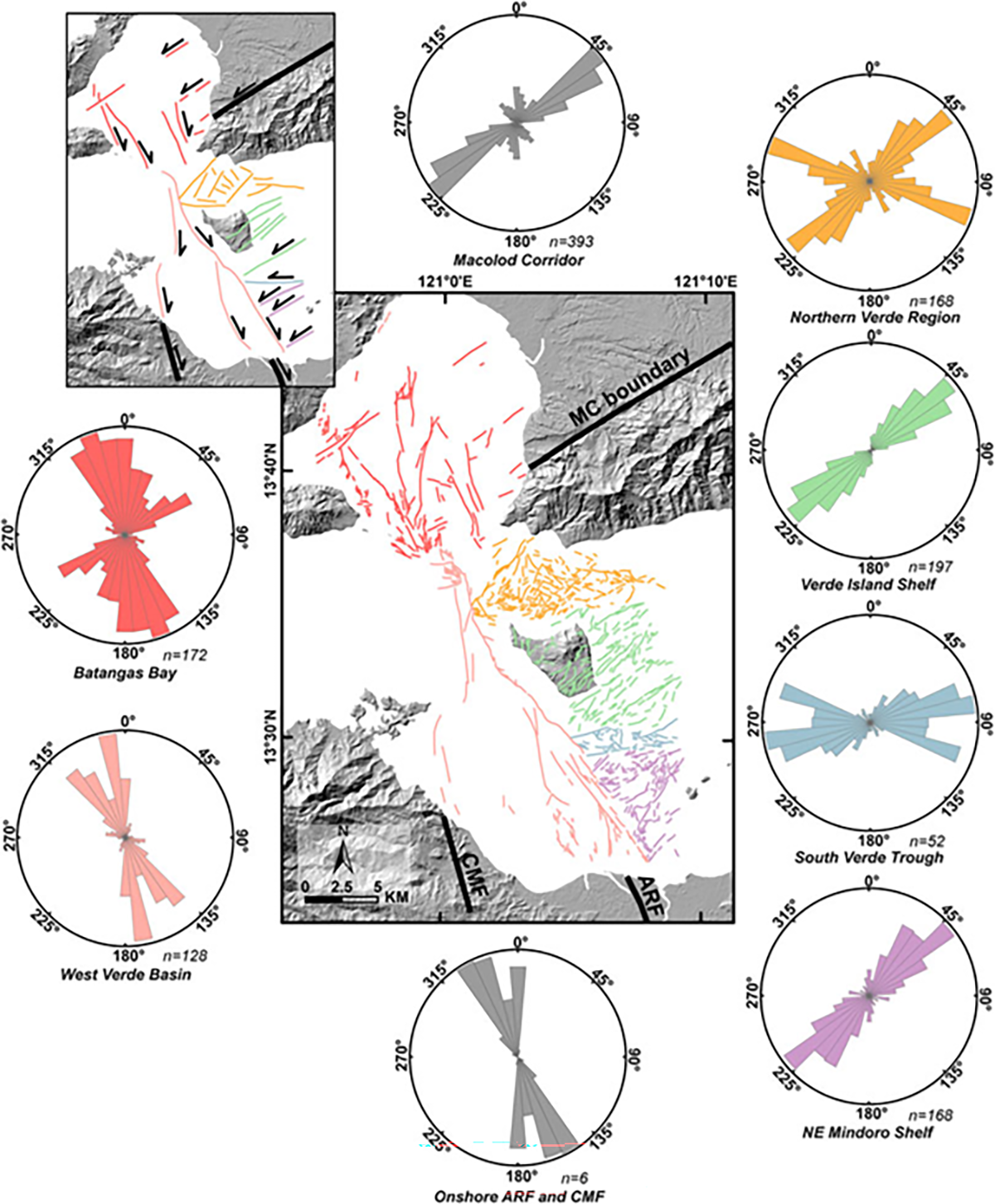
This research mapped the active offshore faults in Batangas Bay and part of Verde Island Passage. It is of such importance since the area of interest is the site of the 1994 Mindoro Earthquake and the 2017 Batangas Earthquake. The only known fault in the vicinity is the Verde Passage Fault but the characteristics of the two earthquakes do not match the nature of the Verde Passage Fault. Seafloor mapping using high resolution bathymetry from NAMRIA and subbottom profiles acquired by UP MSI and PHIVOLCS revealed eight fault systems (Central Mindoro Fault, Aglubang River Fault, Batangas Bay Fault System, Macolod Corridor, North Verde Fault System, Central Verde Fault System, South Verde Fault, and Northeast Mindoro Fault System). Correlation with earthquake locations determined the source of the 1994 Mindoro Earthquake and 2017 Batangas Earthquake as the Aglubang River Fault and Batangas Bay Fault System, respectively. Coulomb stress transfer modelling was also performed to infer whether the earthquake events are related and if they imparted stress to the other nearby faults. The modelling showed that the 1994 Mindoro Earthquake contributed to the occurrence of the 2017 Batangas Earthquake and the two earthquakes increased the stress, and therefore the probability of earthquake occurrence, along the other mapped fault systems.
Significance
Mapping of active faults in offshore areas remains to be a challenging task in the Philippines due to the logistical and financial difficulties. Nevertheless, such type of research is much needed for a more accurate seismic hazard and risk assessment. The lack of knowledge on the presence of active faults led to unprecedented earthquakes and unanticipated damages in the nearby communities. Such was the case in offshore southern Batangas where the occurrence of the 1994 Mindoro Earthquake and 2017 Batangas Earthquake cannot be attributed to the only known fault in the area due to different characteristics. Seafloor mapping in this work revealed eight fault systems spanning Batangas Bay to northeast Mindoro and determined the source faults of the 1994 Mindoro Earthquake and 2017 Batangas Earthquake, respectively. This work showed the importance of mapping of active offshore faults and highlights the need to expand this type of work to the other areas of the tectonically-active Philippines where much remains undiscovered.
Photos

Authors:
Keanu Jershon S. Sarmiento (Marine Science Institute, University of the Philippines; National Institute of Geological Sciences, University of the Philippines)
Mario Aurelio (National Institute of Geological Sciences, University of the Philippines)
Paul Caesar M. Flores (Marine Science Institute, University of the Philippines)
Anne Drew V. Carrillo (Marine Science Institute, University of the Philippines)
Bryan J. Marfito (Department of Science and Technology – Philippine Institute of Volcanology and Seismology)
Maria Isabel T. Abigania (Department of Science and Technology – Philippine Institute of Volcanology and Seismology)
Arturo S. Daag (Department of Science and Technology – Philippine Institute of Volcanology and Seismology)
Fernando P. Siringan (Marine Science Institute, University of the Philippines)
Read the full article: https://www.frontiersin.org/articles/10.3389/feart.2021.801670/full