
Bulletin 02: Oil spill trajectory model and satellite imagery shows oil slick trajectory and affected areas
Photo: Philippine Coast Guard
MSI’s scientists, with the concurrence of the DENR, are recommending to warn coastal communities—especially those on the eastern and southern sides of Oriental Mindoro, including Caluya Island (Northwestern Antique), and potentially Cuyo Island of Palawan—to prepare for the possibility that the oil spill could reach their shores.
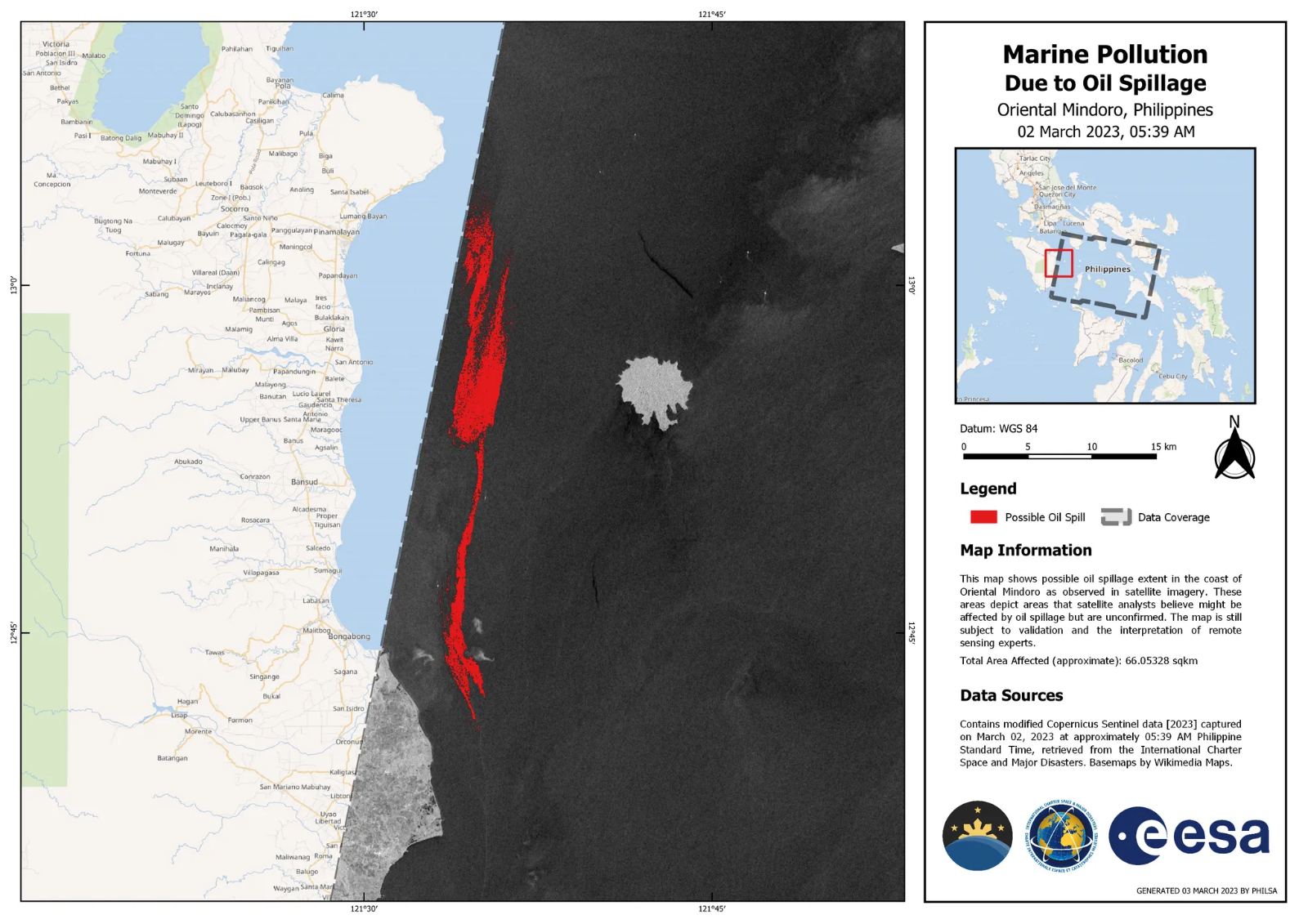
Aerial surveys by the DENR and UP MSI on the morning of March 3 (8-9AM) estimated the slick to be around 25 km long and between 300 to 500 m wide. It is roughly oriented northeast to southwest, with its tail end situated in Pola Bay. This was also confirmed by the satellite images released by the Philippine Space Agency (PhilSA).
To help the communities and the agencies prepare, UP MSI oceanographer Dr. Cesar L. Villanoy and his team developed an oil spill trajectory model to forecast the track and the transport of the slick over the next four days (March 3-7, 2023) based on prevailing weather patterns and conditions, and on recent information on the location of the slicks.
Three trajectory model runs were generated:
Scenario 1 (Run 1) considers possible transport northwards towards the Verde Island Passage (VIP), making Calapan and Puerto Galera as possible affected areas.
Scenario 3 (Run 3) considers the continuous release of oil from the suspected seepage location but was also initialized with the latest information on the location of the observed slick. This model shows the oil slick being transported southwards, which has now been confirmed to have reached the coasts of Pinamalayan and Bongabong. It also shows that some of the slick may pass through Caluya Island (Northwestern Antique) and could eventually reach Cuyo Island in Sulu Sea. The model however, again, only shows potential trajectories in the next four days.
These models are now being used by the DENR to direct efforts on the ground. Images provided by PhilSA are in agreement with the model (Scenario 3) about the movement of the slick. Though agencies looked at the feasibility of deploying booms to contain surface oil within its boundaries, both the experts and the PCG aired concern that the strong waves caused by the prevailing Amihan winds might render the oil booms ineffective at containing the spill.
The public and local governments along the projected routes are now being warned about the possibility of oil slick deposition in many coastal areas south of Mindoro. Aside from the ecological damage to these habitats, damage from the oil slick will also have an economic impact on livelihood and food sources. The public is encouraged to report any sighting of oil slick to authorities and adhere to public guidance to prevent its harmful effects. New model runs will be made available in the coming days.
*Description of Hydrodynamic Model: The model used is the General NOAA Operational Modeling Environment (GNOME) for predicting the fate and transport of pollutants, such as oil, spilled into the ocean. The model for the Mindoro spill uses surface velocity fields from the Real-Time Ocean Forecast System (RTOFS) and surface winds from the National Center for Environmental Prediction Global Forecast System. Spill location was specified based on visual reports by personnel on site. Forecasts for the next 6 days will be run everyday as needed. Information about the model is available in https://response.restoration.noaa.gov/gnomesuite.